California Cities Already Picked The Land Where Housing Goes.
Every city had to name the exact parcels where its housing quota gets built. We matched all of it to real parcels and joined it to who owns the land — affordable and market-rate capacity alike.
On 31,435 of those parcels, a qualifying affordable project must be approved by right. No rezoning, no hearing, no year of meetings.
Land The City Has Already Blessed.
Each parcel was formally designated for housing through a public process that already happened. Zoning, committed rezoning, and utility service are known before you start — a faster yes or no before real money goes in.
So Why Isn't Everyone Building On It?
Raw, the data is unusable: hundreds of jurisdictions, hundreds of formats, the same land listed more than once, keyed to nothing you can look up.
Properant streamlined it to one row per parcel — 529,448 records matched at 99.8% — and tied each one to ownership, recorded debt, foreclosure stage, tax delinquency, and liens. Until now there were three ways in.
Read The PDFs Yourself
One housing plan at a time. Copy parcel numbers by hand, then look up each owner. Repeat for every city.
Pay A Consultant
The same reading, scoped to a few cities, delivered weeks later as a memo that is stale the moment a parcel trades.
Or Search All Of It At Once
Every jurisdiction, every designated parcel — filtered by units, income category, by-right status, and ownership. Seconds, statewide.
And We Don't Take The Filing's Word For It.
We Check The Vacant Ones From Above
A parcel called vacant can be years out of date. We check each one against overhead imagery, so a lot that quietly filled in never reaches your list as vacant — and the ones that are clear are marked verified.
And Whether Utilities Are Already There
Service at the property line decides whether a project pencils. Utility status is carried parcel by parcel, so you can filter straight to land that is ready to build.
31,435 Parcels Where By-Right Approval Applies.
No hearing to lose. No discretionary review to wait out. Approval becomes a schedule instead of a gamble.
When a city keeps re-listing the same parcel to meet its affordable quota, state law takes the vote away: a project with at least a fifth of its units affordable to lower-income households cannot be denied. No conditional use permit, no hearing, no project-level environmental review — objective standards only.
That removes the risk that kills most affordable deals. You can underwrite the parcel, price it honestly, and take a defensible timeline to investors.
parcels statewide carry the flag that triggers it — filter for them directly.
“A nonvacant site identified … in a prior housing element and a vacant site that has been included in two or more consecutive planning periods … shall not be deemed adequate to accommodate a portion of the housing need for lower income households … unless … the site is subject to a program in the housing element requiring rezoning … to allow residential use by right for housing developments in which at least 20 percent of the units are affordable to lower income households.”
A Real By-Right Parcel. 486 Units Planned, Verified Vacant, Utilities On Site.
3.66 acres in San Jose, carried across earlier housing plans, owned free and clear by an absentee LLC. One search result, opened.
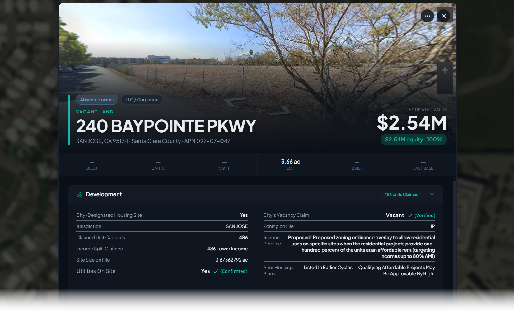
Listed In Earlier Cycles
San Jose has carried this parcel across earlier housing plans — the record the by-right test starts from.
486 Units, All Lower Income
The capacity already counted for this parcel, entirely lower income.
Nothing Owed On It
$2.54M estimated value at 100% equity — no lender payoff, no short sale.
Absentee Corporate Owner
An LLC with a mailing address away from the parcel, on vacant land with utilities at the property. A holder, not a user.
That Parcel Came Out Of One Search.
Every line below is a filter you stack in the same query, across all 452 jurisdictions.
A List Of Parcels Is Not A Deal. Ownership Is.
The state's list says where a city wants housing. It doesn't say who owns the land, what they owe, or whether they have a reason to sell. Every designated parcel here sits on the full record for that property.
Who Owns It
Owner of record, mailing address, whether they live there, and their other California parcels.
What They Owe
Open mortgages and liens reconciled against recorded releases.
Whether They Are Stuck
Foreclosure stage, tax delinquency, HOA liens, and involuntary liens.
What The Lot Really Is
Lot size, zoning, and use as recorded — plus measured geometry from its mapped boundary.
The list is free to anyone willing to read it. Knowing that the owner of a by-right parcel bought in 2006, owes more than it is worth, and is behind on taxes is what makes the call worth making.
Stack A Distress Signal On Top And Every Name Has A Reason To Answer.
A designated parcel says where you can build. A distress signal says who might sell. Layer them and you have a call sheet that refills every day.
The Owner Who Needs Out
A by-right parcel whose owner just got a foreclosure filing. A clock is running, and the city cannot block your project.
The Long Carry
Empty designated land, years of unpaid tax, an owner who lives elsewhere. Carrying cost with no upside turns a holder into a seller.
The Clean Close
Real density, owned free and clear on a low basis. No lender payoff, no short-sale approval — they can close fast if the number is right.
Every distress signal on the platform stacks the same way.
Filters Built For How You Source, Affordable Or Market Rate.
Every designation field is searchable statewide and stacks with county, city, lot size, zoning, ownership, and distress.
Capacity is filed across every income category, so the land works for either kind of project. By-right is what turns on for affordable units.
The same parcel arrives more than once. Each record is matched to a real parcel and collapsed to one row carrying its strongest designation.
- City-Designated Housing Site
- The jurisdiction designated this parcel for housing.
- Claimed Unit Capacity
- How many units it is counted for. Filter by range.
- Income Category Claimed
- Lower, moderate, or above moderate.
- Listed In Prior Housing Plans
- The by-right trigger. 31,435 parcels.
- Rezone Pipeline
- A rezoning for housing is committed. 80,564 parcels.
- City Claims Vacant
- Designated as vacant land. 41,712 parcels.
- Utilities On Site
- Service already at the parcel — filter straight to build-ready land.
Or say it in plain English — “city designated housing parcels in Fresno over 20 units” — and the AI search sets the filters, which you can adjust before running.
Built On A Record That Moves Daily.
A designated parcel is a starting point. Everything underneath it refreshes every day.
Ownership Changes
New deeds and transfers land daily, so a parcel that trades stops looking like a lead.
Debt And Distress
Mortgages reconciled against releases, foreclosure filings by stage, tax delinquency, HOA and involuntary liens.
Every County, One Search
All 58 counties in a single query. No portals, no per-report fees.
The designated layer is only useful because of what sits under it: statewide ownership, recorded debt, and distress, refreshed every day.
Start Where The Answer Is Already Yes.
380,887 designated parcels across 53 counties, joined to ownership, debt, and distress. No consultants, no PDFs.
Statewide coverage · No credit card required